Local official on severe weather: 'We cannot stress enough today, HAVE A PLAN. PLEASE!’
"All ingredients are coming together" for northeast Kansas to see a "high-impact severe weather event" between 4 and 11 p.m. Monday, reporters were told by a meteorologist with the Topeka Weather Service's Topeka office.
"We're very confident that we're going to see storms in the area today," meteorologist Sarah Teefey said during a webinar held late Monday morning.
She recommended the cancellation of any events set for Monday evening, particularly those taking place outdoors.
'HAVE A PLAN. PLEASE!’
Shawnee County emergency management director Dusty Nichols wrote Monday afternoon on his department’s Facebook page: "It appears nearly the entire weather expert (real and amateur) community across the nation is indicating the severe weather potential today. We cannot stress enough today, HAVE A PLAN. PLEASE!"
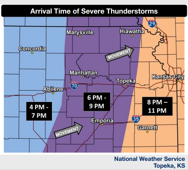
One slide Teefey showed told of how "giant" hail 2 inches or more in diameter would be most likely west of a line from roughly Marysville south to Manhattan southeast to Emporia.
"Storms will eventually organize into a line and this would reduce the risk for giant hail with time," it said.
When will it happen?
Storms will move into north-central Kansas between 3 and 5 p.m., Teefey said.
Additional storms will develop across south-central Kansas and move northeast between 5 and 7 p.m. toward the Topeka area, she said.
Storms are expected to form in central Kansas, creating a line from north to south and sweeping east across the state while generally going from southwest to northeast, said a graphic posted on the website of the weather service's Topeka office
Topeka, Hiawatha, Emporia, Manhattan and Marysville are all part of an area expected to see storms between 6 and 9 p.m., it said.
What's possible?
Strong tornadoes, high winds, large hail and flash flooding will all be possible with the storms involved, Teefey said.
The storms will be moving fast, she said, adding that they are expected to affect all of the area the weather service's Topeka office covers in north-central, northeast and east-central Kansas.
Probabilities will be medium to high for high winds, medium to high for large hail, medium for tornadoes and low to medium for flooding, said a graphic posted on the website of the weather service's Topeka office.
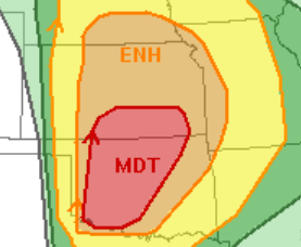
What does the Storm Prediction Center say?
The eastern two-thirds of the storm will see "enhanced" moderate" chances for severe weather Monday, said a convective outlook issued by the weather service's Storm Prediction Center in Norman, Oklahoma.
"Moderate" chances, which are more serious than "enhanced," are expected in part of southern Kansas.
A graphic posted on the website of the weather service's Topeka office indicated the capital city would be part of an area that would see a 10-14% chance of tornadoes Monday within 25 miles of any given point.
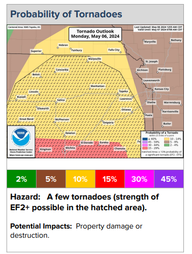
It said Topeka would be part of an area that would see a 30-44% chance of high winds within 25 miles of any given point, and a 15-29% chance of large hail within 25 miles of any given point.
The state has seen 33 tornadoes so far this year, including three in Shawnee County, according to the weather service.
On average, the state sees about 95 tornadoes a year.
Contact Tim Hrenchir at threnchir@gannett.com or 785-213-5934.
This article originally appeared on Topeka Capital-Journal: Severe storms expected to sweep eastward across Kansas on Monday
